‘No traces of life’: Israel’s Ecocide in Gaza 2023-2024
Forensic Architecture
‘No traces of life’: Israel’s Ecocide in Gaza 2023-2024
Date of Incident
07 Oct 2023 – Ongoing
Location
Gaza
Publication Date
29 Mar 2024
Commissioned By
Self-Initiated
Additional Funding
None
Collaborators
Ain Media Gaza
Forums
Legal Process, Media

Building on Forensic Architecture’s previous investigation into herbicidal warfare and its effects on Palestinian farmers along the eastern perimeter of the occupied Gaza Strip, this investigation marks Land Day in Palestine by examining the systematic targeting of orchards and greenhouses by Israeli forces since October 2023. Our analysis reveals that this destruction is a widespread and deliberate act of ecocide that has exacerbated the ongoing catastrophic famine in Gaza and is part of a wider pattern of deliberately depriving Palestinians of critical resources for survival.

Since 2014, Palestinian farmers along Gaza’s perimeter have seen their crops sprayed by airborne herbicides and regularly bulldozed, and have themselves faced sniper fire by the Israeli occupation forces. Along that engineered ‘border’, sophisticated systems of fences and surveillance reinforce a military buffer zone.

Since October 2023, Israel’s ground invasion has uprooted most of these orchards and systematically targeted agricultural farmlands and infrastructure throughout the besieged Strip.

This investigation builds on our existing collaborations with local farmers’ associations and agricultural workers, to reveal the ongoing Israeli destruction of vegetation in Gaza and its effects on the food security and means of life for Palestinians.

Last remaining orchards

For the past decade, the Abu Suffiyeh family has cultivated one of the last olive, pomegranate, and citrus orchards along the eastern perimeter of Gaza, in a district called East Jabaliya.

Directly facing the Israeli-imposed buffer zone, these orchards and the lands cultivated by other farmers in this area were often threatened by bulldozing by the Israeli occupation forces, which declared that any vegetation higher than 1 metre in the vicinity of their military ‘no-go’ area is a security threat, and must be flattened. In this way, the continued existence of the Abu Suffiyeh farm and its neighbours confronted the colonial imaginary of a flattened Gazan landscape.
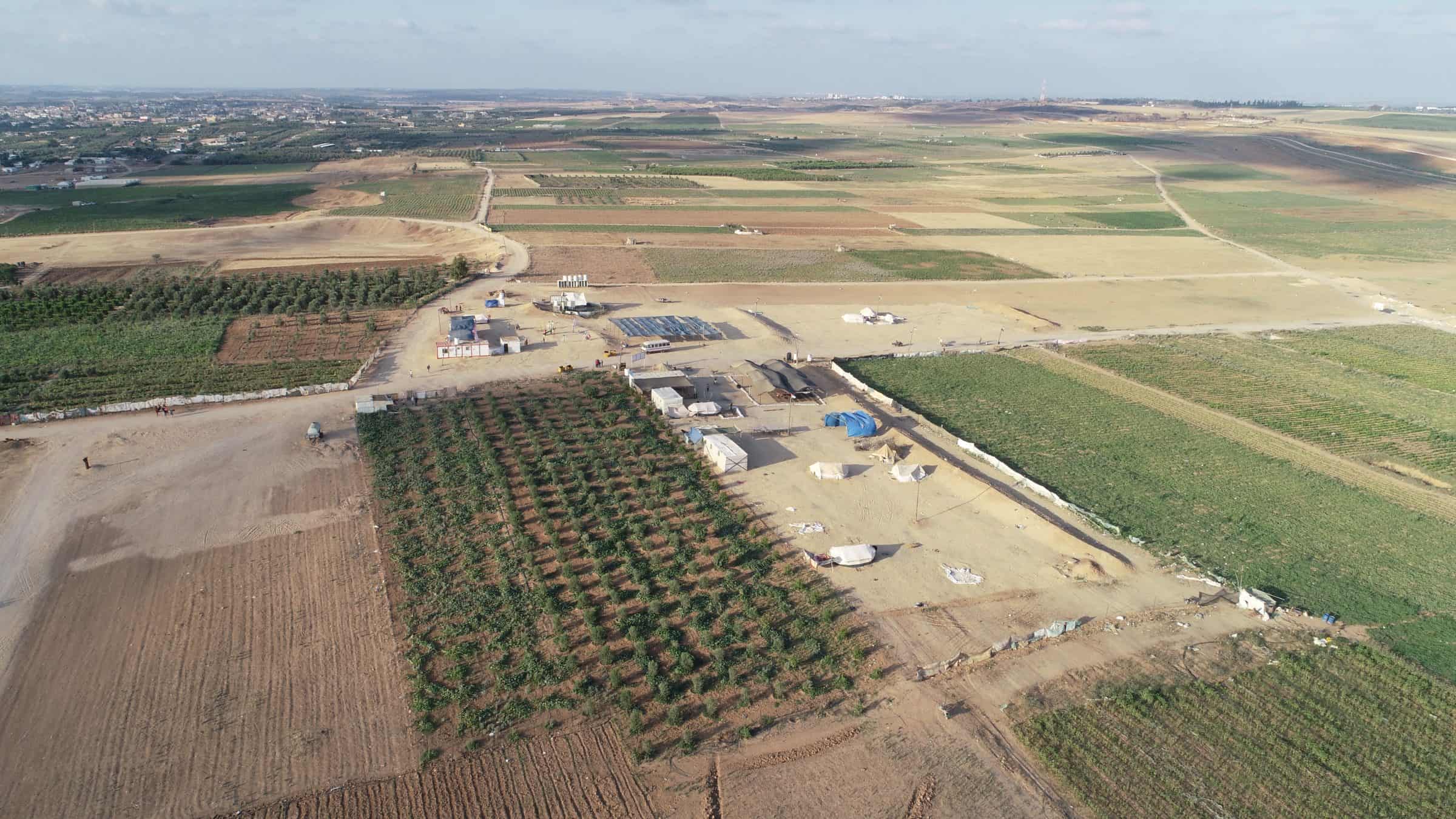
 - Figure 1. Image (© Ain Media Gaza) from 2019 of the Abu Suffiyeh family’s thriving olive, pomegranate, and citrus orchards in East Jabaliya, on the eastern perimeter of Gaza.
Figure 1. Image (© Ain Media Gaza) from 2019 of the Abu Suffiyeh family’s thriving olive, pomegranate, and citrus orchards in East Jabaliya, on the eastern perimeter of Gaza.

Later, during the 2018 civilian protests, known as the Great March of Return and the Breaking of the Siege, the areas surrounding the Abu Suffiyeh farm became a gathering place for protesters confronting the occupation.

Even as the decades-long Israeli blockade of the Gaza Strip prevented access to clean water and vital farming materials, through careful and assiduous tending, Abu Suffiyeh’s orchard nevertheless grew tall.
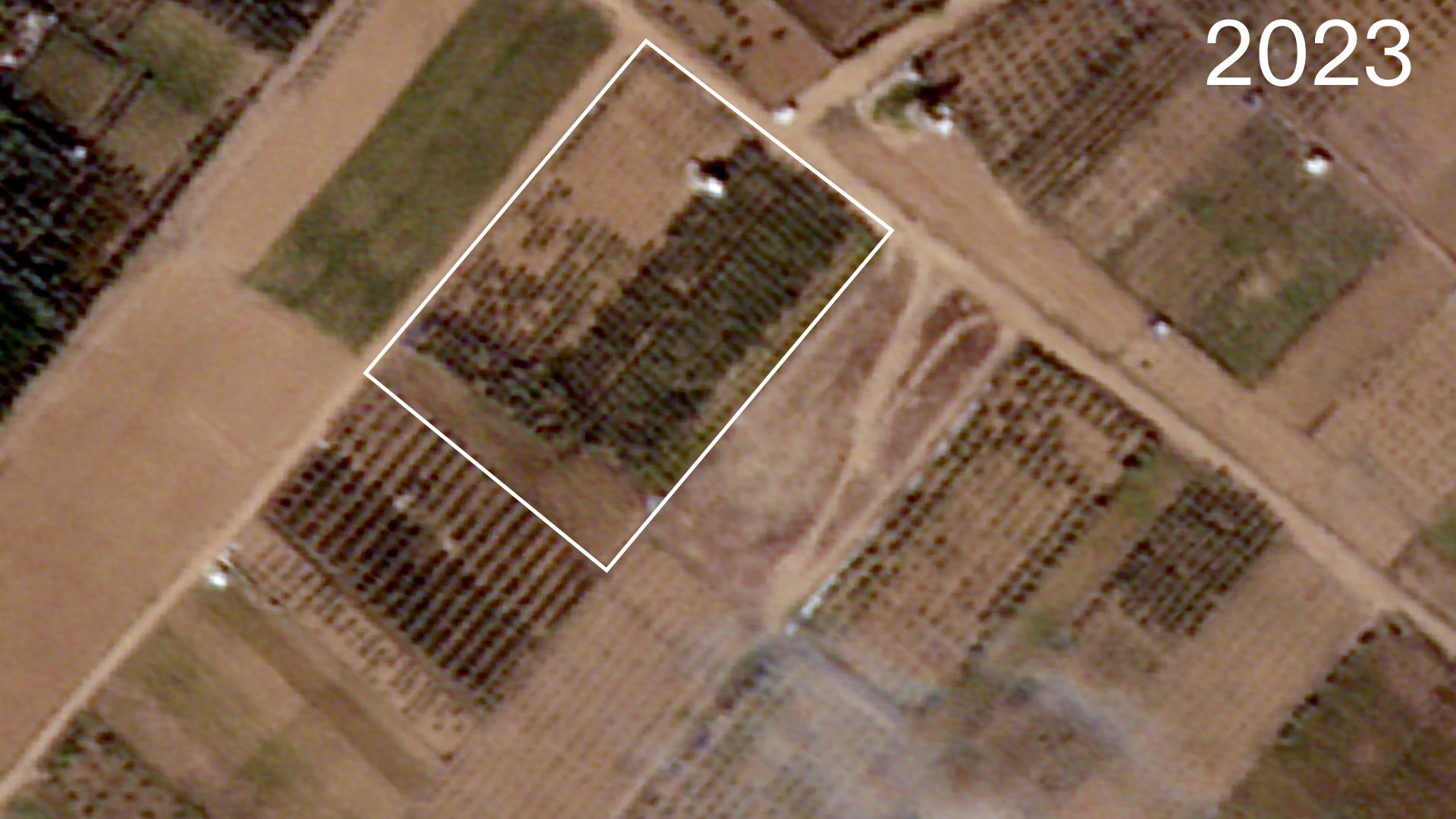
 - Figure 2. Satellite image (©️ Planet Labs PBC) from November 2023 shows the growth of the Abu Suffiyeh family’s orchard.
Figure 2. Satellite image (©️ Planet Labs PBC) from November 2023 shows the growth of the Abu Suffiyeh family’s orchard.

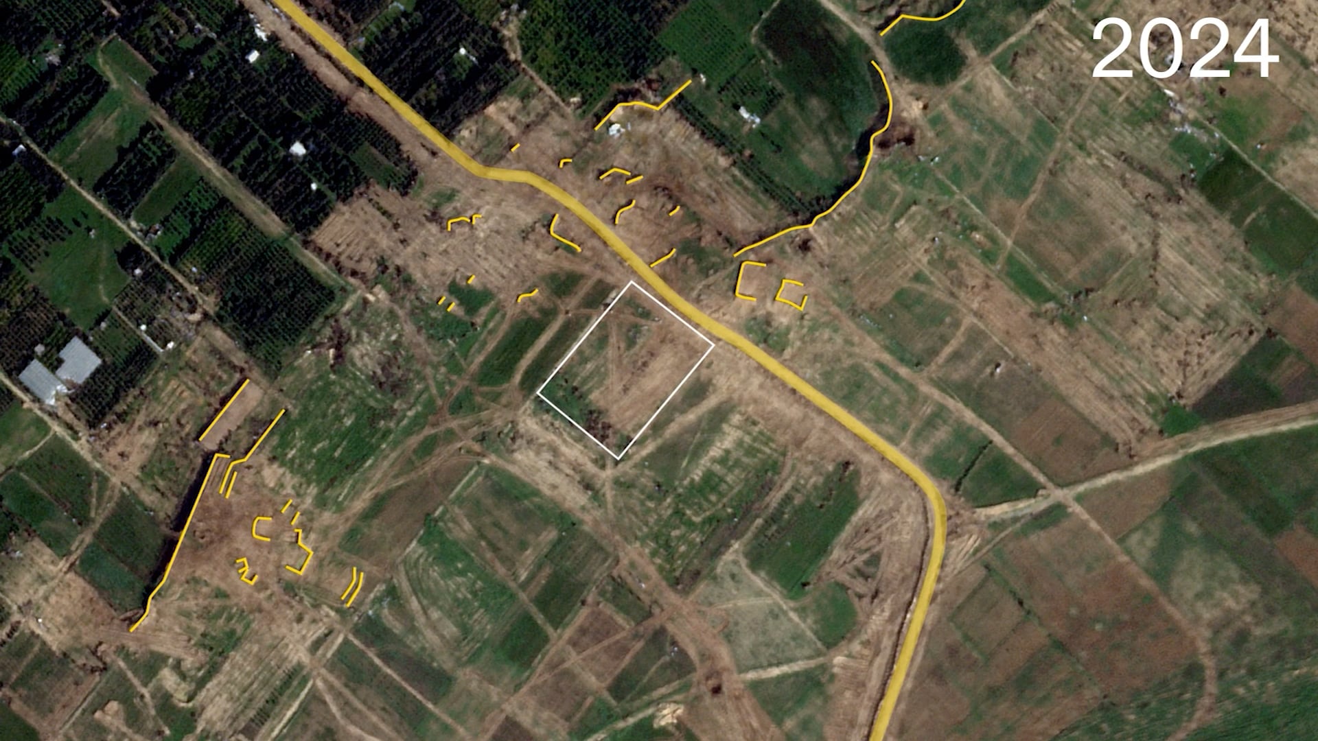
But the family’s efforts to preserve their land were unable to withstand the recent Israeli military incursions: satellite imagery from January 2024 shows that the farm was destroyed by the Israeli ground invasion. Earth berms have been raised by bulldozers to create military bases, and a new road has been carved through the landscape.
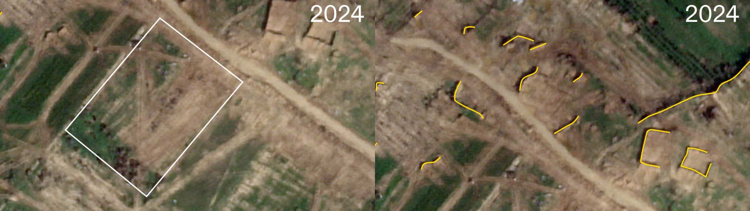
 - Figure 3. Annotated satellite image (© Planet Labs PBC) from January 2024 of the Abu Suffiyeh family’s orchards reveals the destruction of the farm (in white) by the Israeli military and the construction of fortifications and a new road (in yellow).
Figure 3. Annotated satellite image (© Planet Labs PBC) from January 2024 of the Abu Suffiyeh family’s orchards reveals the destruction of the farm (in white) by the Israeli military and the construction of fortifications and a new road (in yellow).

Together, these earthworks have transformed a previously productive Palestinian agricultural area into a colonial military outpost.

Using satellite and aerial images, we were able to trace the changing landscape of the Abu Suffiyeh farm and neighbouring agricultural lands over decades. Historical aerial photography shows Palestinian fields and orchards in the area before the Israeli occupation in 1967. Despite the Israeli land expropriation and nearby settlement construction that followed, cultivation continued for decades, until the 2000s, when this agriculturally rich area was uprooted and flattened to build roads and infrastructure to support the illegal settlements. Following the removal of the Israeli-Jewish settlements in 2005, despite regular attacks and lack of access to key farming materials, Palestinian farmers like the Abu Suffiyeh family were able to successfully restore the land.

Figure 4. Cartographic regression shows the area where the Abu Suffiyeh farm is located over decades. (Satellite image sources: © Planet Labs PBC, 01 November 2023, © Planet Labs PBC, 20 January 2024, © www.geomolg.ps, 2004, © Google Earth, 2010, ©SPOT CIB, 23 December 1986, © Declassified, 27 June 1963)

Taken together, this analysis reveals persistent Palestinian cultivation of these farmlands in the face of forced changes to the landscape by the Israeli occupation.

Ecocide in Gaza

Prior to 2023, Gaza contained 170 square kilometres of agricultural land, accounting for about 47 percent of its total area. These fields and orchards served as a local source of food security for besieged Palestinians.
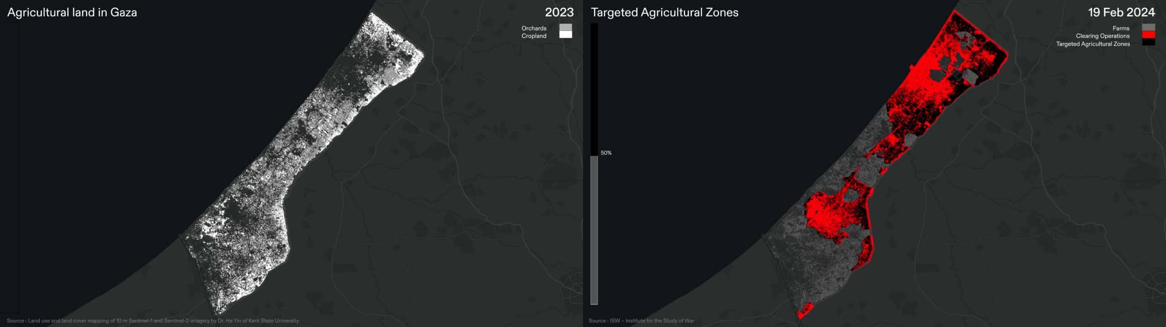
 - Figure 5. Map (left) of orchards (grey) and croplands (white) in Gaza from 6 October 2023 (based on land use and land cover mapping of 10 m Sentinel-1 and Sentinel-2 imagery by Dr. He Yin of Kent State University), compared to a map (right) of the Israeli ground invasion of Gaza as of 19 February 2024. (Forensic Architecture)
Figure 5. Map (left) of orchards (grey) and croplands (white) in Gaza from 6 October 2023 (based on land use and land cover mapping of 10 m Sentinel-1 and Sentinel-2 imagery by Dr. He Yin of Kent State University), compared to a map (right) of the Israeli ground invasion of Gaza as of 19 February 2024. (Forensic Architecture)

Our analysis shows that Israel’s ground invasion has advanced over nearly 50 percent of Gazan farms and orchards. We used remote sensing to measure the scale of agricultural destruction resulting from this military activity, by comparing the region’s ‘vegetation index’ (an indicator of the health and robustness of plant life, measured by analysing satellite imagery) before and after the invasion. This comparison reveals that as of March 2024, of the agricultural areas targeted, approximately 40 percent of the land in Gaza previously used for food production has been destroyed.
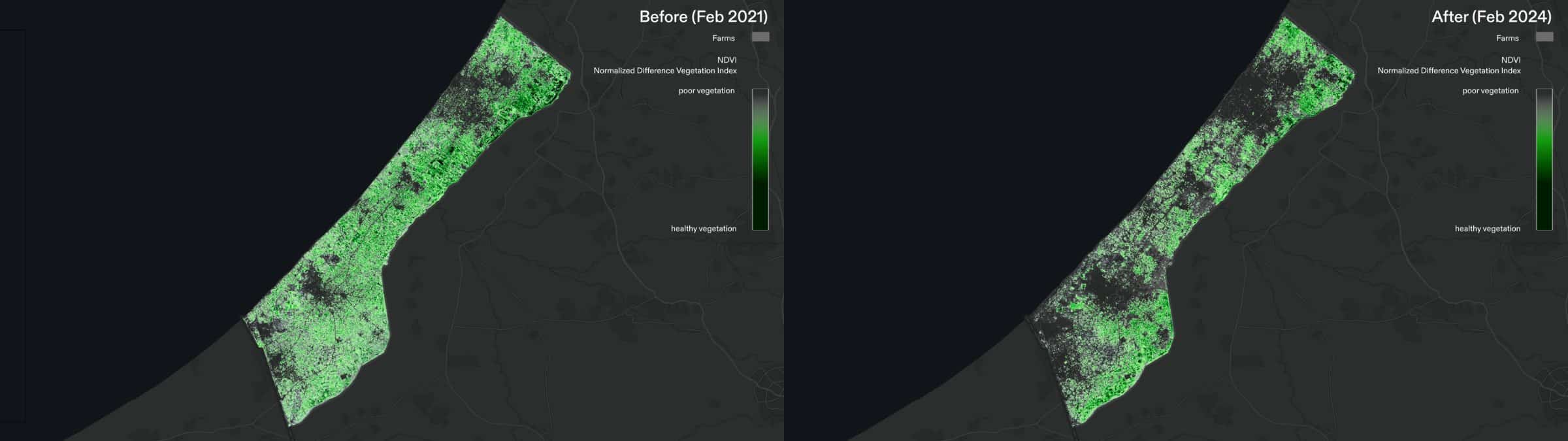
 - Figure 6. NDVI analysis shows areas covered with vegetation. Map (left) shows plant life in Gaza in February 2021, and map (right) shows plant life in February 2024. Cloud free mosaics of Sentinel-2 satellite data between 20 January  and 8 February  of 2021 and 2024 is used as the bases of this NDVI study. (Forensic Architecture)
Figure 6. NDVI analysis shows areas covered with vegetation. Map (left) shows plant life in Gaza in February 2021, and map (right) shows plant life in February 2024. Cloud free mosaics of Sentinel-2 satellite data between 20 January  and 8 February of 2021 and 2024 is used as the bases of this NDVI study. (Forensic Architecture)

The uprooting of agriculture along Gaza’s perimeter may also indicate that the Israeli army is expanding its ‘buffer zone’, further shrinking the liveable space for Palestinians.
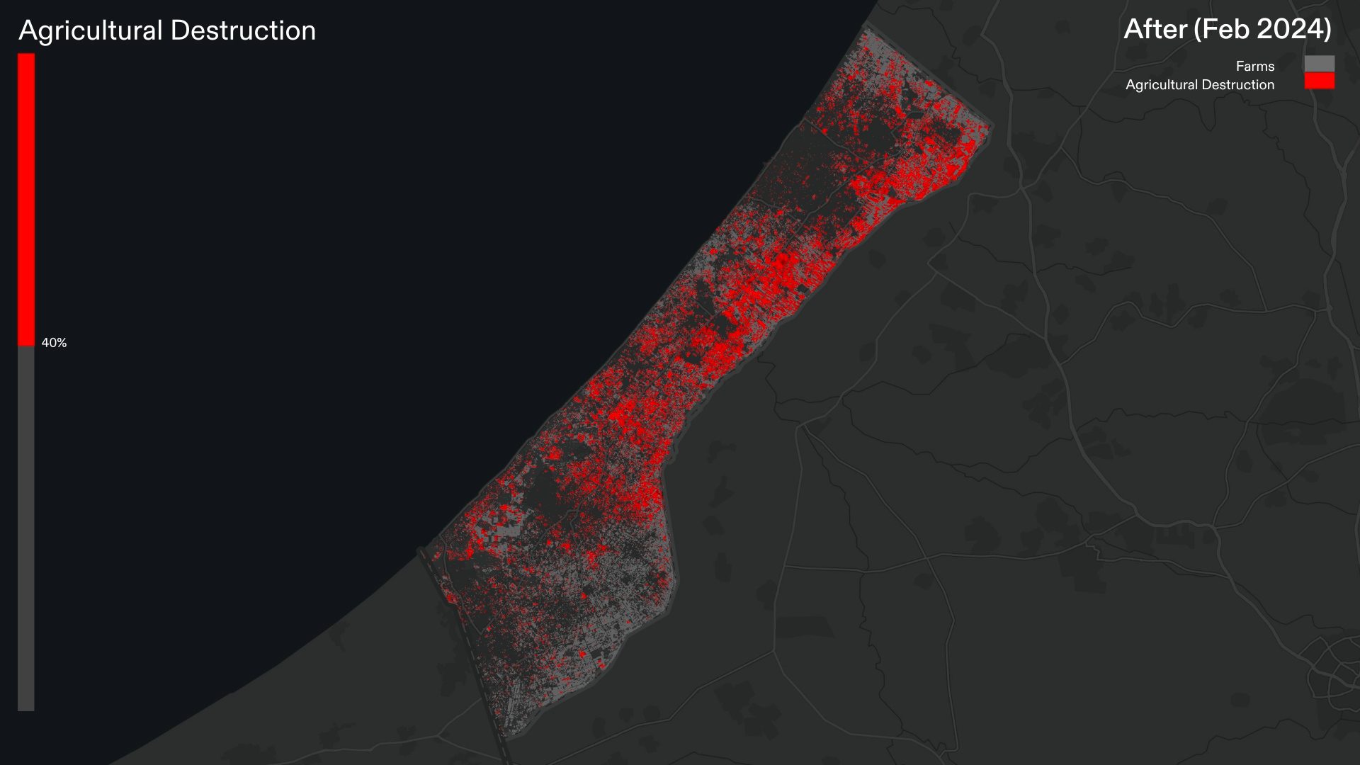
 - Figure 7. A comparison of NDVI analysis of agricultural fields and orchards before and after Oct 2023, indicates a loss of 40 % of the total food resources. Darker shades of red indicate higher levels of destruction. (Forensic Architecture)
Figure 7. A comparison of NDVI analysis of agricultural fields and orchards before and after Oct 2023, indicates a loss of 40 % of the total food resources. Darker shades of red indicate higher levels of destruction. (Forensic Architecture)

Targeting agricultural infrastructure

Vital agricultural infrastructure such as greenhouses has also been systematically destroyed since the launch of the ground invasion.

In the early weeks of the Israeli ground invasion, satellite imagery shows extensive destruction of greenhouses where, between October 2023 and March 2024, nearly one third of Gaza’s greenhouses have been destroyed.
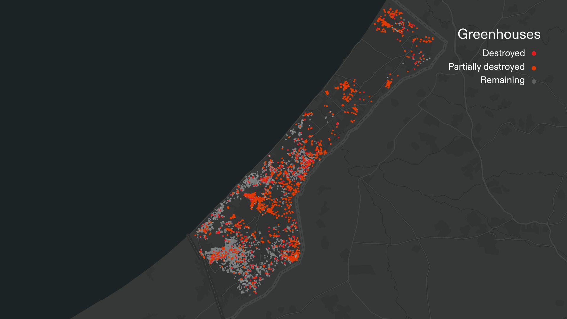
 - Figure 8. Since October 2023, almost one third of Gaza’s greenhouses have been destroyed. (Forensic Architecture)
Figure 8. Since October 2023, almost one third of Gaza’s greenhouses have been destroyed. (Forensic Architecture)

In total, Forensic Architecture has identified more than 2,000 agricultural sites, including farms and greenhouses, which have been destroyed since October 2023, often to be replaced with Israeli military earthworks.

This destruction has been most intense in the northern part of Gaza, where 90 percent of greenhouses were destroyed in the early stages of the ground invasion.
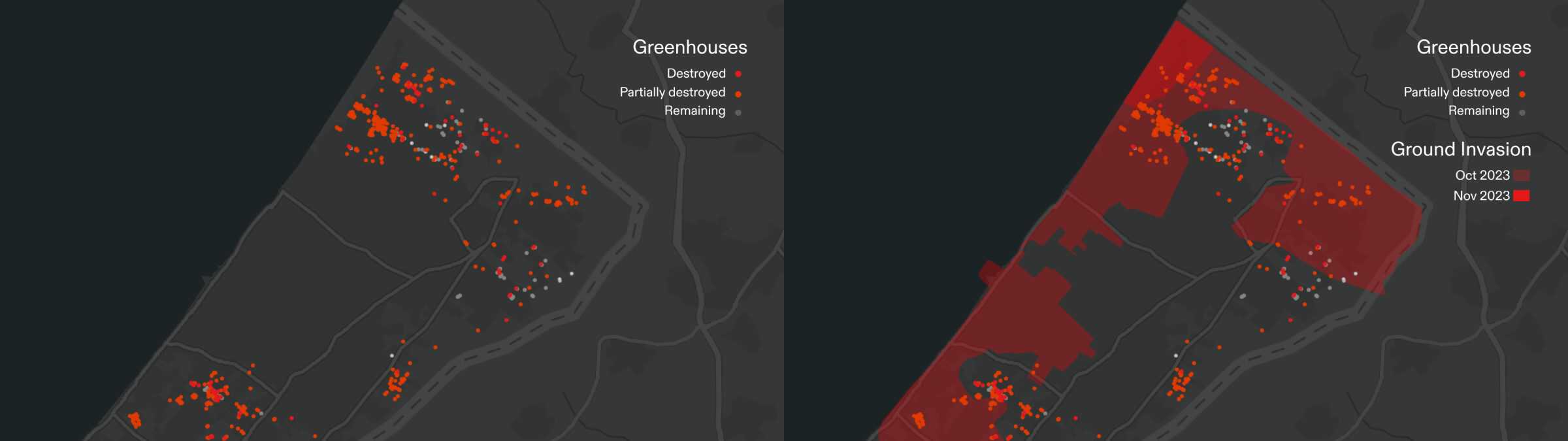
 - Figure 9. Map (left) shows destroyed (red) and partially destroyed (orange) greenhouses in northern Gaza since October 2023. Map (right) shows the destroyed greenhouses in relation to the area occupied during the Israeli ground invasion as of December 2023. (Forensic Architecture)
Figure 9. Map (left) shows destroyed (red) and partially destroyed (orange) greenhouses in northern Gaza since October 2023. Map (right) shows the destroyed greenhouses in relation to the area occupied during the Israeli ground invasion as of December 2023. (Forensic Architecture)

As the Israeli military advances south, destruction of agricultural land and infrastructure moves with it. We observe that 40 percent of the greenhouses in the areas around the southern city of Khan Younis, where many hundreds of thousands of Palestinians are now displaced, have been destroyed since January 2024.
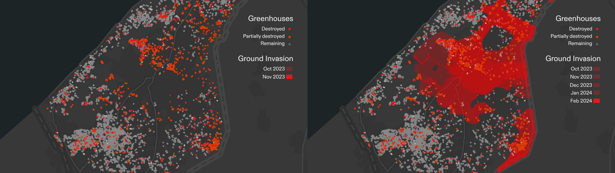
 - Figure 10. Map (left) shows destroyed (red) and partially destroyed (orange) greenhouses in southern Gaza since October 2023. Map (right) shows the destroyed greenhouses in relation to the area occupied during the Israeli ground invasion as of February 2024. (Forensic Architecture)
Figure 10. Map (left) shows destroyed (red) and partially destroyed (orange) greenhouses in southern Gaza since October 2023. Map (right) shows the destroyed greenhouses in relation to the area occupied during the Israeli ground invasion as of February 2024. (Forensic Architecture)

Military support vehicles and tractors accompany the Israeli ground invasion, routinely building earthworks to reinforce military outposts. Once those vehicles depart, they leave behind a devastated and unliveable area.

Figure 11. Annotated satellite images (© Planet Labs PBC) from 30 October 2023, 1 November 2023 and 2 December 2023 of a cluster of greenhouses in Beit Lahiya reveals their systematic destruction by the Israeli military.

The destruction of agricultural land and infrastructure in Gaza is a deliberate act of ecocide and a critical dimension of Israel’s genocidal campaign. The targeted farms and greenhouses are fundamental to local food production for a population already under a decades-long siege. The effects of this systematic agricultural destruction are exacerbated by other deliberate acts of deprivation of critical resources for Palestinian survival in Gaza. These acts include, the well-reported catastrophic and Israeli-made famine ongoing in Gaza, continued obstruction of humanitarian aid destined for Gaza, the destruction of medical infrastructure, the destruction beyond repair of other areas of civilian infrastructure, including bakeries, schools, mosques, churches and cultural heritage sites.

Updates

Update — 20 August 2024

Since October 2023, we have documented the clearing of farms and orchards east of Gaza City belonging to the now-displaced Abu Suffiyeh family. Between November 2023 and June 2024, satellite imagery shows that the majority of Palestinian homes and farmland within 1km of the eastern perimeter of Gaza had been cleared by Israeli forces, and a new road constructed providing direct military access to Gaza City.

Our analysis of satellite imagery from November 2023 through July 2024 reveals evidence of a new Israeli military corridor east of Gaza City. This new corridor constitutes the second Israeli-built east-west passage through Gaza, after the so-called ‘Netzarim Corridor’. Together, these corridors are infrastructural indications of an intended permanent Israeli military presence in the northern parts of the occupied Gaza Strip.

Play Video
Forensic Architecture Team
Principal Investigator
Researcher-in-Charge
Research
Project Support
Research Assistance
Collaborators
Exhibitions
16 Oct – 21 Dec 2025
'No Traces of Life'
DaDa Marrakech
16 Oct 2025 – 01 Mar 2026
Bells and Cannons
Contemporary Art Centre, Vilnius
25 – 27 Sep 2025
Art as Counter-Archive: Documenting Violence in the Era of Post-Truth Politics
Kampnagel, Hamburg
04 Sep 2025 – 01 Feb 2026
Histories of Ecology
Museu de Arte de São Paulo
08 May – 14 Jun 2025
OFF Biennale
CEU Open Gallery, Budapest
04 Apr – 11 May 2025
MEDPHOTO 5: We Can't Breathe
EIGHT: Critical Institute for Arts and Politics
05 Dec 2024 – 15 Mar 2025
War on the Senses / War of the Senses
Museum of Contemporary Art Skopje
Press
03 Apr 2025
Novara Media
How Forensic Architecture Mapped the Gaza Genocide
06 Feb 2025
Yale Environment 360
As War Halts, the Environmental Devastation in Gaza Runs Deep
26 Sep 2024
Euro-Med Human Rights Monitor
Gaza: Israel’s destruction of hundreds of acres of agricultural land is a destruction of the food basket of the starving and a systematic continuation of the tools of genocide
05 Sep 2024
Truthout
Report: Israel Demolishing Nearly Everything in “Buffer Zone” Along Gaza Border
01 Sep 2024
Pagine Esteri
GAZA. Israel builds new corridor for permanent control
01 Sep 2024
Turkiye Today
Satellite imagery reveals new Gaza corridor, raises concerns over Israeli army presence
30 Aug 2024
Sky News
Israel establishing infrastructure for long-term military presence in Gaza, satellite images suggest
23 Aug 2024
iNewsgr.com
Satellite images reveal Israel building new land corridor inside Gaza
22 Aug 2024
Truthout
Israel Using Ceasefire Talks to Expand Colonization of Palestine, UN Expert Says
22 Aug 2024
L’Orient-Le Jour
Trêve à Gaza : que sont les corridors de Philadelphie et Netzarim ?
22 Aug 2024
Escenario Mundial
Un análisis alerta por la ocupación permanente de Israel en Gaza
22 Aug 2024
Tribun News
Satellite Images Reveal Israel is Building New Land Corridor, New Israeli Military Corridor East of Gaza
21 Aug 2024
The Cradle
Satellite images reveal Israel building new land corridor inside Gaza: Report
21 Aug 2024
Truthout
New Israeli Road in Gaza Suggests Plan for Permanent Occupation, Analysis Finds
17 Aug 2024
DW News
Will Gazans ever be able to produce their own food again?
13 Aug 2024
El Hovo News
Israel has created a new corridor for a long-term presence in Gaza
11 Aug 2024
Common Dreams
A Note on Noam Chomsky and Climate Collapse
23 Jul 2024
What Is Ecocide? Gaza’s Environmental Crisis
22 Jul 2024
What Israel is doing in Gaza is ‘ecocide’ – destruction of environment: Activist
24 Jun 2024
Alvaremoz
Yaşam İzi Kalmadı: İsrail’in Gazze’deki Ekokırımı
20 Jun 2024
CodePink
Forgotten Victims of the Gaza War: Environment and Climate
09 May 2024
The New Arab
Ecocide in Gaza: The environmental impact of Israel's war
09 May 2024
The New Arab
Ecocide in Gaza: The environmental impact of Israel's war
07 May 2024
La Vanguardia
La factura medioambiental de la guerra en Gaza
06 May 2024
Bianet
"Palestinians, whose agricultural lands were destroyed, produce in their gardens"
05 May 2024
Anadolu Agency
Ecocide: Israel's systematic destruction of Palestinian agriculture revealed
02 May 2024
Mizane.info
Gaza: Israel accused of committing environmental ecocide
30 Apr 2024
Europa Today
The price of war: environmental devastation in Gaza
29 Apr 2024
Reporterre
À Gaza, des activistes dénoncent un crime d’écocide
24 Apr 2024
France 24
Gaza : l'agriculture victime de la guerre
23 Apr 2024
Al Mayadeen Español
Genocidio en Gaza deja caos mundial en el Día de la Tierra
11 Apr 2024
L'Espresso
Con l'ecocidio di Gaza, Israele ha cancellato ogni possibile futuro sulla Striscia
08 Apr 2024
CNN Greece
«Οικοκτονία» στη Γάζα: Διερευνάται αν η περιβαλλοντική καταστροφή ισοδυναμεί με έγκλημα πολέμου
07 Apr 2024
Radio-Canada
Après six mois de guerre, Gaza en cartes et en graphiques
07 Apr 2024
El Cohete a la Luna
100 a 1, La Proporción del Terror Israelí
06 Apr 2024
The Independent
تدمير الأراضي الزراعية يسحق فرصة الغزيين الأخيرة لسد الرمق
05 Apr 2024
Ground Report
Ecocide in Gaza: Who will hear and heal its dying environment?
29 Mar 2024
The Guardian
‘Ecocide in Gaza’: does scale of environmental destruction amount to a war crime?
Related Investigations
Herbicidal Warfare in Gaza
Khan Younes, Gaza, Occupied Palestinian Territories · 01 Jan 2014 – Ongoing
Humanitarian Violence in Gaza
Gaza, Occupied Palestinian Territories · 07 Oct 2023 – Ongoing
Triple-Chaser
Tijuana-San Diego border, US/Mexico; Gaza, Palestine; and around the world · 26 Nov 2018
German Arms Exports to Israel
Germany, Israel, Palestine · 07.10.2023 - Ongoing
Attacks on Aid in Gaza: Preliminary Findings
Gaza, Palestine · 08 Oct 2023 – 25 Apr 2024
The Killing of Hind Rajab
Gaza City, Gaza · 29 Jan 2024
A Cartography of Genocide: Israel's Conduct in Gaza since October 2023
Gaza, Occupied Palestinian Territories · 07 Oct 2023 – Ongoing
Israel's Destruction of the Port of Gaza
Port of Gaza, Gaza City · October 2023 – January 2024
The Massacre at Tur Al-Zagh: Al-Dawayima, 29 October 1948
Al-Dawayima, Palestine · 29 Oct 1948